
IfcBuilding
Definition from ISO 6707-1:1989:
Construction work that has the provision of shelter for its occupants
or contents as one of its main purpose and is normally designed to
stand permanently in one place.
Definition from IAI: A building represents
a structure that provides shelter for its occupants or contents and
stands in one place. The building is also used to provide a basic
element within the spatial structure hierarchy for the components of a
building project (together with site, storey, and space).
A building is (if specified) associated to a site. A building
may span over several connected or disconnected buildings. Therefore
building complex provides for a collection of buildings included in a
site. A building can also be decomposed in (vertical) parts, where each
part defines a building section. This is defined by the composition
type attribute of the supertype IfcSpatialStructureElements
which is interpreted as follow:
- COMPLEX = building complex
- ELEMENT = building
- PARTIAL = building section
HISTORY:
New entity in IFC Release 1.0.
Property Set Use Definition:
The property sets relating to the IfcBuilding
are defined by the IfcPropertySet and attached by
the IfcRelDefinesByProperties relationship. It is
accessible by the inverse IsDefinedBy relationship.
The following property set definitions specific to the IfcBuilding
are part of this IFC release:
Quantity Use Definition:
The quantities relating to the IfcBuilding
are defined by the IfcElementQuantity and attached
by the IfcRelDefinesByProperties. The following
quantities are foreseen, but will be subjected to the local standard of
measurement:
| Name |
Description |
Value Type |
| TotalHeight |
Calculated total height of the building, measured
from the level of terrain to the top part of the building |
IfcQuantityLength |
| SiteCoverage |
Calculated coverage of the building site area that
is occupied by the building (also referred to as footprint). |
IfcQuantityArea |
| GrossFloorArea |
Calculated sum of all areas covered by the
building (normally including
the area of construction elements).
The exact definition and calculation rules depend on the
method of measurement used. |
IfcQuantityArea |
| NetFloorArea |
Calculated sum of all usable areas covered by the
building (normally excluding the area of construction elements). The
exact definition and calculation rules depend on the method of
measurement used. |
IfcQuantityArea |
| GrossVolume |
Calculated gross volume of all areas enclosed by
the building (normally
including the area of construction elements). The exact definition and calculation rules
depend on the
method of measurement used. |
IfcQuantityVolume |
| NetVolume |
Calculated net volume of all areas enclosed by
the building (normally
excluding the area of construction elements). The exact definition and calculation rules
depend on the
method of measurement used. |
IfcQuantityVolume |
Spatial Structure Use Definition
The IfcBuilding
is used to build the spatial structure of a building (that serves as
the primary project breakdown and is required to be hierarchical). The
spatial structure elements are linked together by using the objectified
relationship IfcRelAggregates.
The IfcBuilding references them
by its inverse relationships:
- IfcBuilding.Decomposes
-- referencing (IfcSite || IfcBuilding)
by IfcRelAggregates.RelatingObject,
If it refers to another instance of IfcBuilding,
the referenced IfcBuilding
needs to have a different and higher CompositionType,
i.e. COMPLEX (if the other IfcBuilding
has ELEMENT), or ELEMENT (if the other IfcBuilding
has
PARTIAL).
- IfcBuilding.IsDecomposedBy
-- referencing (IfcBuilding || IfcBuildingStorey)
by IfcRelAggregates.RelatedObjects.
If it refers to another instance of IfcBuilding,
the
referenced IfcBuilding
needs to have a different and lower CompositionType,
i.e. ELEMENT (if the
other IfcBuilding
has COMPLEX), or PARTIAL (if the other IfcBuilding
has
ELEMENT).
If there are building elements and/or other elements directly related
to the IfcBuilding (like a curtain
wall spanning several stories), they are
associated with the IfcBuilding
by using
the objectified relationship IfcRelContainedInSpatialStructure.
The IfcBuilding
references them by its inverse relationship:
- IfcBuilding.ContainsElements
-- referencing any subtype of IfcProduct
(with the exception of other spatial structure element) by IfcRelContainedInSpatialStructure.RelatedElements.
Attribute Use Definition:
 |
The heated space within a
Building shall be handled by the IfcZone, including
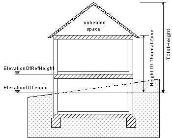
the property for overall height of the heated space in the Building.
The following figure shall define the interpretation of building
heights and elevations for IfcBuilding.
The ElevationOfRefHeight
is used to give the height above sea level of the internal height 0.00.
The height 0.00 is often used as a building internal reference height
and equal to the floor finish level of the ground floor.
|
Geometry Use Definitions:
The geometric representation of IfcBuilding is given by the IfcProductDefinitionShape
and IfcLocalPlacement, allowing multiple geometric
representation.
Local Placement
The local placement for IfcBuilding is
defined in its supertype IfcProduct. It is defined
by the IfcLocalPlacement, which defines the local
coordinate system that is referenced by all geometric representations.
- The PlacementRelTo relationship of IfcLocalPlacement
shall point (if relative placement is used) to the IfcSpatialStructureElement
of type "IfcSite", or of type "IfcBuilding" (e.g. to position a
building relative to a building complex, or a building section to a
building).
- If the relative placement is not used, the absolute
placement is defined within the world coordinate system.
Geometric Representations
Currently, the use of a 2D 'FootPrint' representation of type
'GeometricCurveSet' and a 3D 'Body' representation of type 'Brep' is
supported.
Foot Print Representation
The foot print representation of IfcBuilding
is given by either a single 2D curve (such as IfcPolyline
or IfcCompositeCurve), or by a list of 2D curves
(in case of inner boundaries), if the building has an independent
geometric representation.
The representation identifier and type of this geometric
representation of IfcBuilding is:
- IfcShapeRepresentation.RepresentationIdentifier
= 'FootPrint'
- IfcShapeRepresentation.RepresentationType
= 'GeometricCurveSet'
Body Representation
The body (or solid model) geometric representation (if the
building has an independent geometric representation) of IfcBuilding
is defined using faceted B-Rep capabilities (with or without voids),
based on the IfcFacetedBrep or on the IfcFacetedBrepWithVoids.
The representation identifier and type of this representation
of IfcBuilding is:
- IfcShapeRepresentation.RepresentationIdentifier
= 'Body'
- IfcShapeRepresentation.RepresentationType
= 'Brep'
Since the building shape is usually described by the exterior
building elements, an independent shape representation shall only be
given, if the building is exposed independently from its constituting
elements.
EXPRESS specification:
Attribute definitions:
| ElevationOfRefHeight
|
:
|
Elevation above sea level of the reference height used for all storey elevation measures, equals to height
0.0. It is usually the ground floor level.
|
| ElevationOfTerrain
|
:
|
Elevation above the minimal terrain level around the foot print of the building, given in elevation above
sea level.
|
| BuildingAddress
|
:
|
Address given to the building for postal purposes.
|
Inheritance graph